Modeling
Data Analysis and Assimilation
The Data Analysis and Assimilation group (William Randel, Boris Khattatov, Steven Massie, Liwen Pan, and Fei Wu) focuses on analysis and interpretation of global constituent data sets obtained from satellite observations, in conjunction with meteorological data analyses. Recent work has included studies of the dynamical and chemical behavior of the tropical tropopause region, the behavior of water vapor in polar regions, and the assimilation of chemical measurements from satellites.
Massie led a study examining the spatial distributions of cirrus near the tropical tropopause in relation to deep convection (as monitored by measurements of outgoing longwave radiation). This is aimed at understanding the formation mechanism of thin cirrus clouds, which are ubiquitous in this region. The cirrus observations were derived from multi-wavelength aerosol measurements made by the Upper Atmosphere Research Satellite (UARS), where the wavelength information is used to distinguish cirrus and background aerosol observations. Trajectory analyses demonstrated that approximately half of the cirrus observations are associated with deep convection within a day's travel time, while the other half are distant from convection. The multi-wavelength data were also used to estimate that thin cirrus clouds near the tropical tropopause sequesters approximately 5% of the available gas phase water vapor.
Andrew Gettelman (ASP Postdoctoral fellow), Randel and Massie collaborated on work that quantified the influence of convection on dynamical fields and water vapor in the tropical tropopause region. This work was based on data analysis and a CCM2 model simulation of the effects of El Nino events on the tropical tropopause, using observed El Nino changes as a 'natural experiment'. During El Nino 'warm events', large-scale tropical convection shifts eastward from Indonesia into the central Pacific Ocean (in response to corresponding sea surface temperature (SST) changes). In concert with these changes in convection, there are shifts in the tropical tropopause thermal structure, together with changes in the distribution of water vapor and large-scale cirrus. By specifying realistic SST variations, the CCM2 runs were able to mimic many of the observed changes in convection, tropopause dynamical fields, water vapor and cirrus. These correlated changes are all linked to describe mechanisms that control the water vapor distribution in the tropical tropopause region.
A further study by Gettelman and Randel used three-dimensional trajectory calculations with a realistic microphysical model to simulate the spatial distribution of water vapor and ice clouds near the tropical tropopause. An intriguing feature of satellite observations is that minima in water vapor (and ozone) near the tropopause are spatially separated from convection and the regions of coldest tropical temperatures. The trajectory simulations are able to reproduce the observed spatial structures, and demonstrate that the tropospheric meridional circulation (the Hadley cell) is primarily responsible for the spatial separation of convection and dehydrated air.
Randel collaborated with Rolando Garcia (RMP Group) on a study quantifying the strength and variability of mean upwelling in the tropical lower stratosphere (the Brewer-Dobson circulation), based on momentum and thermodynamic balances derived from global meteorological data. This is the first analysis of transient variability in tropical upwelling, and showed that a majority of the variance occurs on time scales of ~10-40 days. This suggests that transport of mass and constituents from the troposphere into the stratosphere occurs episodically, rather than as a slow annual cycle. Calculations based on the global momentum balance quantify that variability in the tropical upwelling is produced as a result of transience in the subtropics, associated primarily with midlatitude synoptic and planetary wave variability.
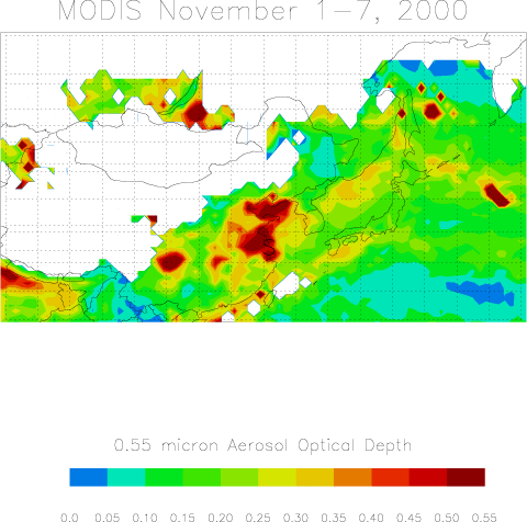
The Mega city Impacts on the Regional and Global Environment (MIRAGE) initiative in ACD will quantify the spatial scales that pollution has on the atmosphere downwind of large urban/industrial regions. Massie is taking a lead role in the use of satellite measurements for MIRAGE studies. One project involves analysis of MODIS aerosol extinction measurements, with the aim of quantifying the spatial extent of urban pollution events. Initial results show the clear signature of large urban centers on local pollution, as shown in the example for Shanghai (Figure 1). Ongoing work in collaboration with Jean Francois Lamarque and Louisa Emmons (MOPITT Group) and Fabiola Navarro (SOARS student) is aimed at understanding the spatial and temporal characteristics of MOPITT carbon monoxide (CO) and the Moderate Resolution Imaging Spectrometer (MODIS) aerosol in the vicinity of Mexico City, along with two dozen urban/rural locations around the world. This work will delineate the relationship between the size of an urban/industrial region to the amount of CO observed by the MOPITT experiment.
Figure 1: MODIS 0.55 micron aerosol optical depth averaged for November 1-7, 2000. S marks the location of Shanghai, China
Liwen Pan led studies of polar chemical variability, based on analysis of Infrared Limb Atmospheric Sounder (ILAS) and Upper Atmosphere Research Satellite (UARS) data. ILAS water vapor, nitrous oxide, nitric acid, and aerosol extinction data were used to identify and study the occurrence of dehydration in the Arctic polar region during January, 1997 (Figure 2). This represents the first observation of Arctic dehydration from a space-borne sensor. Dehydration occurred in January, 1997 following formation of ice clouds between 23-26 km (which is higher than the altitude of dehydration observed in the Antarctic). The ice cloud events that lead to dehydration are connected to synoptic-scale low temperature events (cold pools) over Scandinavia, probably enhanced by mountain-wave effects. An intriguing aspect of these Arctic data is the observation of relatively small gas phase reduction of HNO3 during ice formation, in contrast to large NHO3 loss in the Antarctic during winter. An explanation may be related to the relatively rapid cooling experienced by the Arctic air parcels in transit through synoptic cold pools; the absence of significant gas phase HNO3 loss in the Arctic (in the presence of ice) suggests that HNO3 uptake on polar stratospheric clouds (PSCs) is a slower process than ice formation.
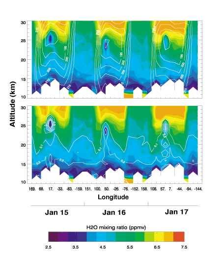
Figure 2: Color image displays ILAS NH water vapor for January 15-17th, 1997. Represented in the image are a total of 37 profiles along the 65 N latitude circle. Contours superimposed are co-located UKMO temperature field (top, 5 K increment) and ILAS 780 nm extinction (bottom, increase 5 steps per decadal range in 10-3 km-1).
Khattatov leads ACD efforts in chemical data assimilation. Assimilation provides a new and optimal approach to determining a set of chemical measurements that contains maximum information about the atmospheric chemical system in collaboration with Lawrence Lyjak and John Gille (HIRDLS Group). Practical applications include designing future instruments and measurement strategies optimized to deliver the maximum amount of information given limited resources. The framework is also useful for determining the maximum measurement errors that guarantee specified prediction errors for a typical set of stratospheric chemicals
Khattatov and Lamarque developed a first practical assimilation scheme for gridding and analysis of the MOPITT CO measurements in the MOZART 2 model. The technique developed is planned to be used for routine operational processing of the MOPITT data. Further work on MOPITT data included collaboration with graduate student Gabrielle Petron (University of Paris), Claire Granier (University of Paris), Lamarque and Valery Yudin (visitor to ACD) to develop an original prototype inversion scheme for deriving surface fluxes of carbon monoxide using MOPITT data and the MOZART 2 model.